
Confidential
BIM Technical Office for the Development of a 1km² Island
Complex Modelling of Topography and Landscaping, Masterplan Development, and BIM Coordination for the Design and Construction Stages
Description
Development of a 1km² Island
Located in a privileged environment, this island is set to become one of the most innovative ultra-luxury destinations. Designed by a renowned Spanish architecture and design practice, the project blends architectural vision, landscape sensitivity, and a strong environmental commitment.
The project includes both real estate and infrastructure developments: a marina, hotel complexes, private residences, museums, beach clubs, and public spaces.
Modelical’s Services
Modelical was selected for this project thanks to its expertise in complex modelling, automation, and BIM coordination for large-scale developments.
The project spanned approximately 2 years and involved over 150 professionals from 10 different companies across several countries.
Our team averaged 10 specialists throughout the duration of the project.
Our main responsibilities included:
- Modelling of landscaping, topography and architecture
- Supervision and development of the model based on the client’s guidelines
- Production of technical documentation
- Production of drawings, sections, data tables, and other documentation for the disciplines mentioned above, including the masterplan package.
- BIM coordination
- Standardisation across models
- Family creation
- Element coding
- Automations and workflows for modelling and documentation management
- Clash detection
- Quality control prior to submissions
- Weekly federated model generation for coordination and progress tracking
- Weekly meetings
Technical Challenges
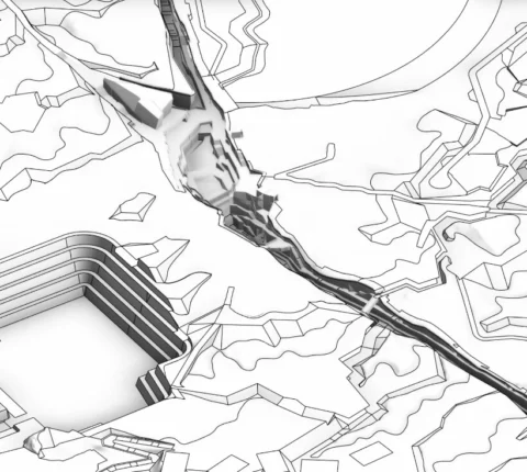
1. Complex modelling of proposed topography
Challenge:
We had to develop the proposed topography model for coordination and documentation purposes. Due to requirements for visualisation and parameterisation, the topography needed to be incorporated as native geometry in Revit. However, given the complexity of the terrain, modelling it directly in Revit was not an efficient approach.
Solution:
We modelled the topography in Rhinoceros, then converted it into native Revit topography using Rhino.Inside. Main paths were generated automatically from LandXML files provided by the engineering team, while the remaining terrain was directly created in Rhino.
2. Automation for complex landscape modelling
Challenge:
The landscape design had to be converted into native Revit floors based on a CAD file, and precisely adapted to the terrain’s topography.
Solution:
Using an automation with Rhino.Inside, the shaded areas in the CAD file (differentiated by layers) were interpreted and converted into native Revit floors with their corresponding types.
These floors were then adapted to the topography by projecting their surfaces onto the terrain using sub-elements.
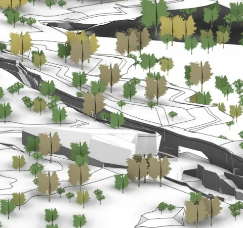
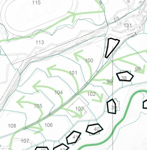
3. Automation for the creation and placement of trees and urban furniture on the topography
Challenge:
The project included a wide variety of tree types and urban furniture elements, all of which had to be accurately positioned in height on the topography.
Solution:
The process was divided into three phases using Rhino.Inside: First, the various types were generated from the existing blocks in the CAD file. Then, instances were placed according to the insertion points of those blocks. Finally, each element was projected to its correct height on the topography.
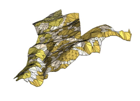
4. Development of an automation for earthworks estimation
Challenge:
The client required a visual representation to roughly identify the areas of greater or lesser earth movement across the topography.
Solution:
Using an automation developed in Grasshopper, a highly segmented 1×1 m grid was generated to cover the entire surface of the terrain. For each cell, the centroid was identified and projected onto both the original and proposed topographies. The height difference between these two points was used to approximate the volume of earthworks. Each cell was colour-coded according to the difference in height: the greater the change, the more intense the applied colour.
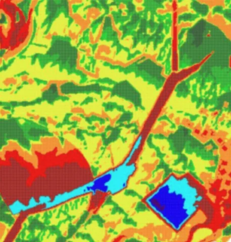
5. Automation development for calculating irrigation demand by area
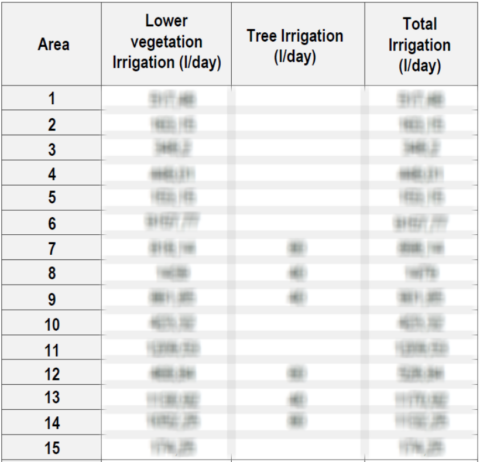
Challenge:
The landscape team needed to estimate the daily water consumption, in litres per day, required to irrigate each parcel of the site.
Solution:
Similarly, using Grasshopper, the surface area occupied by each planting type and the different tree types within each parcel was calculated. Based on this data, water demand was estimated according to the specific requirements of each typology.
6. Automated process for document management
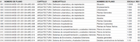
Challenge:
Ensuring consistency between the MIDP and the drawing title block , as well as with the established naming convention.
Solution:
Document management was handled through a spreadsheet-based system combined with Dynamo routines.
The first sheet contained all the information from the MIDP (Model Information Delivery Plan or drawing list) and served as the basis for automatically generating drawings in Revit, with title block fields populated according to the defined data.
The second sheet captured information extracted directly from Revit, allowing discrepancies between the two lists—such as added, modified, or deleted drawings—to be identified using conditional formatting.
Finally, the third sheet focused on deliverables: it compared the list of exported files (PDF, DWG, etc.) with the MIDP, highlighting inconsistencies in naming or file count, also using conditional formatting.
7. Development of a custom solution for weekly model and drawing exports
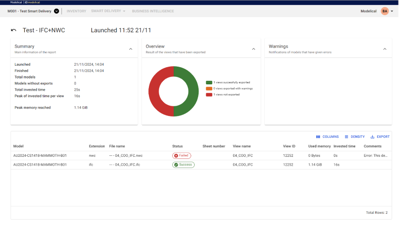
Challenge:
The client required weekly deliverables in multiple formats (PDF, DWG, NWC, IFC), which—given the scale of the project and the volume of drawings—demanded significant time and resources from the team.
Solution:
In coordination with the client, we developed a tool that allowed automatic exports to be scheduled in the required formats. It was only necessary to define the delivery days and the file types, eliminating the need to allocate staff or hardware exclusively for this task.
Key results from a technical perspective
- Number of models: Out of the project’s 712 models, Modelical developed 32models: 21 geometry models and 11 documentation models.
- Clash management: 151 clash tests resolved in Navisworks.
- Families created: 193 Revit families developed from scratch based on client requirements.
- Drawings produced: 809 technical drawings generated.
- Automations: 30 Grasshopper scripts and 96 Dynamo routines developed.
- Interoperability: Combined use of Revit and Rhino via Rhino.Inside.
- Weekly deliverables: Regular exports in PDF, DWG, and NWC formats.
- Communication: Continuous coordination with the various teams through Microsoft Teams
Gallery
